Monday, October 13, 2014

13Oct2014 - Kettlebowl, Lumbercamp and the Hillbilly Hilton

Off on a four day 100-mile century segment of the Ice Age Trail thru Langlade and part of Lincoln County.  Got dropped off Sunday night and started out from the Cocktail Cage Lounge and Bar where the owner lets you camp out back.  Road walk to the start of the Kettlebowl segment is on lightly traveled roads through farm and forested countryside.  Along the way there is a side trail to a large glacial erratic boulder with a memorial, and you pass the old Sherry Cemetery; all that's left of the town of Sherry. 


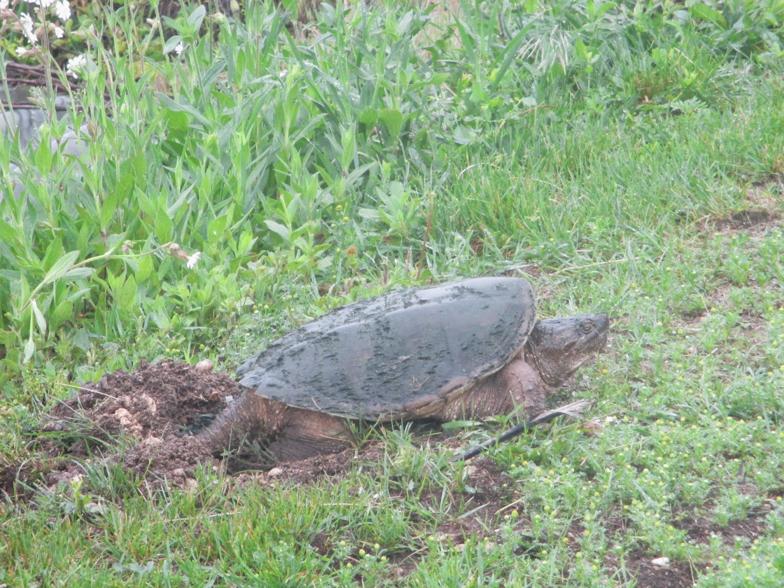
The Kettlebowl segment lives up to it's name as it winds through hilly terrain dotted with huge granit erratics and glacial moraine topography.  Many depressions called "kettle holes," kettlebowls," or "frost pockets" dot the landscape and were formed by remnants of huge blocks of ice; which broke from the ice sheet and when they finally melted left the deep pockets in the landscape.  One very large kettlebowl that I hiked out to demonstrated the unique feature of these frost pockets which is an inverted tree line where the lower levels of the pocket are devoid of woody vegetation similar to higher elevation slopes on mountain tops.  The heavier cooler air at the bottom of the bowl discourages growth.


Parts of this section are overgrown but well marked including parts that overlap with a sled dog trail and a mix of logging roads, and grassy lanes. 

An unmarked side trail leads about a mile over to the Kent Fire Tower.  Perched atop Kent Hill, which at 1903 feet is only 50 feet lower than the state highpoint on Timm's Hill.  I climbed part way up the scary  straight up ladder which while unmarked was rumored to be unsafe before chickening out.  Great views of the remaining color left on the trees. 

The next side trip along the leaf covered trail was to the "Big Stone Hole" another large kettle filled with granite erratics.  Back on the trail I soon hiked right through the Kettlebowl Ski Area where I had a nice lunch on the porch.  The trail shares various cross-country ski trails toward Baker Lake which I heard was the first water available on trail.  Not sure what was ahead I skirted the lake for twenty minutes before giving up and soaking my shoes getting out to clean water from the grass and muddy shoreline.  Little did I know I would not need the water.

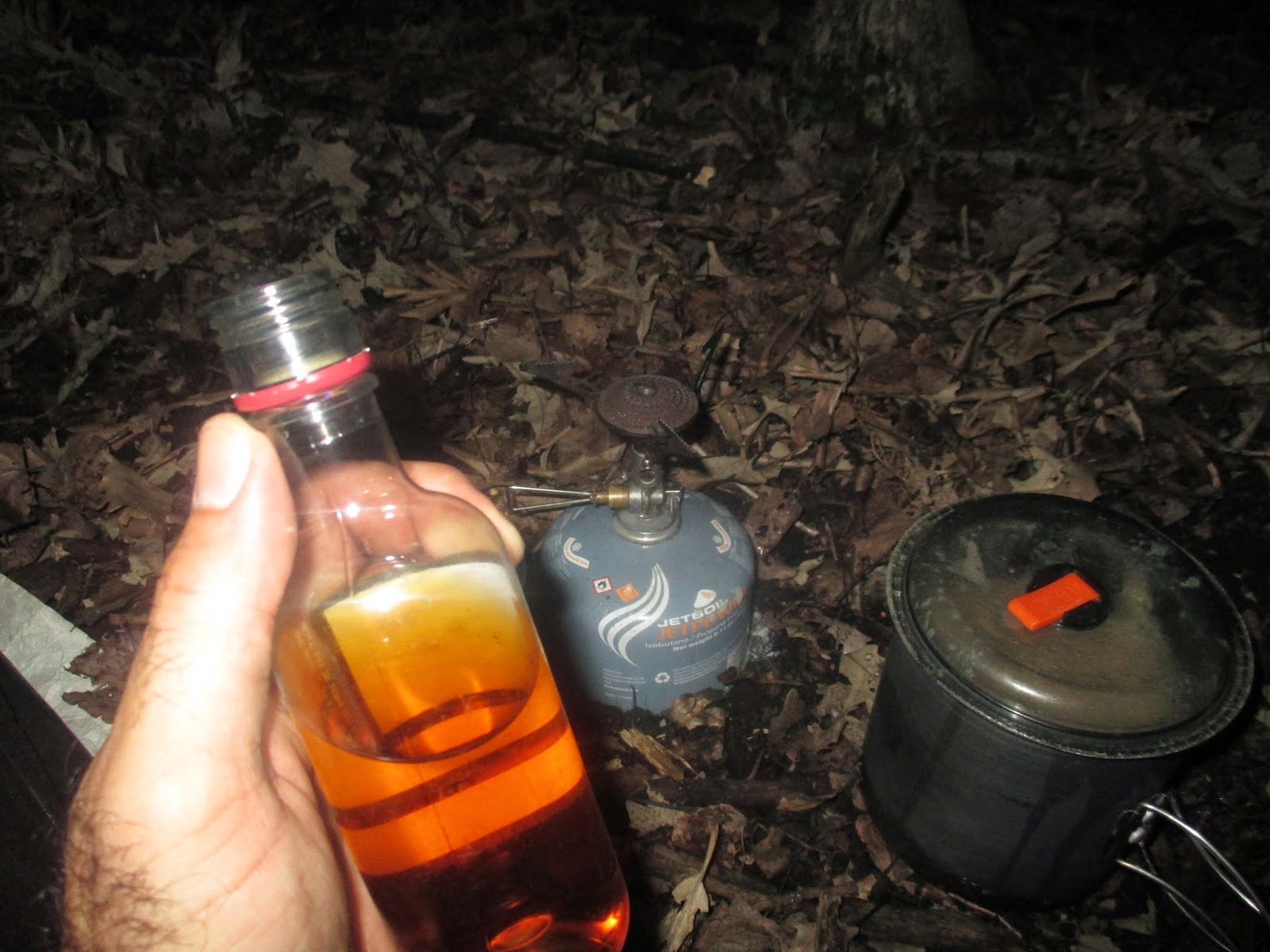
A few miles into the Lumbercamp segment I came to the remains of the Norem Lumber Camp from the 1920's.   All that remains of the camp is a root cellar.  But what a root cellar it is!  The cellar has been renovated and is affectionately called the "Hillbilly Hilton".  Inside are two bunks, a table and some shelving and lots of  bottled water, and a wood stove.  While taking pictures it started to rain.  It was still early afternoon but who wants to hike in the rain when you can stay at the "Hillbilly Hilton"?  It rained all night but I was safe and snug in my root cellar hotel. 


Tuesday, October 7, 2014

7October2014 - Kewaunee River Walk


Back on the Ice Age Trail for a day hike.  Picking up from Krohn's Lake just outside of Algoma the trail follows south along Lake Michigan to Kewaunee.  After staging my car near the end of the Kewaunee River segment on the Ahnapee State Trail; I  rode my bike to where I left off near Krohn's Lake.  Stashed my bike in the woods off an interesting pine wood trail and had a treat of seeing a deer in the fields nearby.


From here to the city of Kewaunee it is a quiet road walk with many views of Lake Michigan, the fall colors in the trees, farms, and fields of corn and sunflowers along the lake shore.  Great views of the harbor from Farther Marquett Memorial Park.


Next I took a quick detour to meander down 1,500 feet of boardwalk through the wetlands on the Kewaunee Nature Walk which ended in a panoramic view of the Kewaunee River from an observation deck.  Along the way several deer jumped across the boardwalk directly in front of me.


The next ten miles follow the Kewaunee River on the Ahnapee State Trail.  Some described this as one of the most scenic sections of a rail-trail in Wisconsin.  Kewaunee County is named for a Potawatomi word meaning “river of the lost.”  Outside Kewaunee the route skirts Bruemmer County Park which has a free zoo but was not open when I hiked through.  And also a fish facility and fish ladder.


After meandering along the river, cross several wooden trestle bridges, and the Besadny State Wildlife Area; I passed through a tunnel under the road in the dark and made it back to my car.  Seven hours to bike one way and hike 21 miles today.

Thursday, June 5, 2014

05June2014 - The road walk to Albany

This morning I hiked through the last section of real forest trail for the day in the Robert Cook Memorial Arboretum.  The last parts were on well maintained trail through the arboretum's self-guided educational section with plenty of informational signs and picnic tables and trailside benches.  At the end was a neat reproduction of a pioneer log cabin from the 1800s.  


The rest of the day was spent on a long paved country road-walk to Albany where I finally picked up the Sugar River State rail-to-trails section where my car was parked.  About 20 miles today.   My feet were wet most of yesterday and I found I had some small blisters that had formed in the cracks that formed on my pruney wrinkled feet.   Guess I'm a little out of shape to be jumping right back to 36 mile days. LOL


While today was pretty country side it was the first long road section without anything particularly interesting other than a stop in the cool shade of an old cemetery.  Glad to finally make it over to the gravel rail-trail Sugar River treadway in Albany, Wisconsin.


Wednesday, June 4, 2014

04June2014 - 36 scenic miles to the Devil's Staircase

Heading out this morning from the Clover Valley State Wildlife Area I came right through Lima Center which must have been an old train stop.  Made it through the night without getting wet but most of this morning was in misting rain and my shoes were quickly soaked by the tall grass on the trail to Lima.

The road walk section from here was actually very nice because it followed some water that had lots of large snapping turtles; several looked to be laying eggs alongside the road.  Passing through the Lima Marsh State Wildlife Area I soon turned off the roads and onto forested trails in the Storrs Lake State Wildlife Area.


Next the trail goes through the town of Milton and past the Milton House Museum, a historical site on the underground railroad.  Waited for the Wisconsin & Southern Railroad train to pass before continuing on past the Northleaf Winery and Bistro.  Sorry to say it wasn't open for the day yet.  From here the trail passed through several parks including straight through the middle of a neat Splash pad water park on it's way toward the Janesville segment.


Next a nice long wooded multi-use path where I encountered this neat carving of the Mammoth Ice Age Trail mascot right in the middle of the trail.  Lots of flowers along this section too.


At Woodcrest Park the IAT follows a spectacular paved multi-use bike trail for many miles.  It's a bikers dream trail from Briar Crest Park, along the Blackhawk Creek, then along the Rock River via Kiwanhis Pond and the Rotary Gardens.  From here it continues all along the waterfront on the Ice Age Way bike trail to Riverside Park and the Devil's Staricase.


Along the way I passed more turtles, many many wildflowers, and the winter site of the Burr Robbins Circus from 1874-1888.  Claims to be the third largest circus in America in it's day.

The paved Ice Age Way Bike Trail ends at Riverside Park and the trail heads into the Devil's Staircase up steep rock steps.  A wonderful rugged footpath follows along the Niagra Escarpment on rocky ledges and stone steps with views of the river below and ledges alongside.  Sections are narrow and steep; some with railings and cables to keep you from falling.  Very nice section.


Ending the day with about 36 miles of hiking by finding a campsite alongside the March Creek near Arbor Ridge and the Robert Cook Memorial Arboretum.

Tuesday, June 3, 2014

03June2014 - Whitewater Lake to Clover Valley

Jumping ahead to the end of the southern Kettle Moraine State Forest for a solo 3-day hike of the Rock County Segment of the IAT.  I'm planning on continuing two threads this summer; one with Dale from the eastern terminus and the second, from here west.  This way I can still hike with Dale and continue longer sections at the same time..

To make the logistics work I made arrangements with the campground host at the Kettle Moraine East Campground to store my bike.  Leaving the smurf mobile at start of the Albany Wisconsin section I road my bike the 42 miles back to Whitewater Lake Recreation Area in the Kettle Moraine State Forest.  After leaving my bike with the campground host I was on trail by 6pm.

Great beginnings!  On my first step onto the Ice Age trail I encountered a sign for a Scenic View.  The Whitewater Lake Segment was a nice section of trail with wildflowers, green forest, and wonderful bog bridges.  Very nice trail out of the Kettle.


From here I followed a series of back roads with more flowers, woods, fields and farms.  Very pretty area making the road walk pleasant.  Soon I came to the "Flowing Well".  Dug by hand in 1895 it was been flowing steadily since and made for a nice stop and water resupply.


Following dirt roads past another farm I noticed a cow in severe distress laying on the ground.  Groaning in pain the other cows started herding around her and I was worried she was dying.  I jumped the barbed wire fence and was planning on hiking across the field to a farm house to warn the rancher but the cow looked to be in such distress that I decided I didn't have time and went closer to see if I could help.  To my surprise the cow got up and immediately gave birth to a baby calf right in front of me.  Wow, that was unexpected.  I watched as the mother licked the baby clean and then noticed I was making the other cows uncomfortable and got my butt out of the field.  Some excitement for the start of my hike!


I ended the day entering the Clover Valley Segment where the Ice Age Trail followed an overgrown pathway through mushroom laden forest and bog bridges.  Finding a quiet spot to camp tonight.  Not a bad little 8-mile hike considering all the logistics to get onto the trail today.  Did not pass any brew pubs this day so I took my queue from the famous "Whiskey Gang" and had a little after dinner sip.